
What you need to know while visiting
Bookmark this page to stay informed with the latest information to make your stay as enjoyable as possible.
Updated June 26, 2026
Quick links
Downtown Parking Enforcement
Reservations required – Maroon Bells, Hanging Lake, and the White River National Forest
Construction, Traffic & Road Conditions
Trail Conditions and Closures
Fire restrictions and alerts
If you are looking for important updates, learn more on our Be Prepared page, which covers the different emergency alert systems in the Roaring Fork Valley.
Parking Enforcement
In June 2025, the Town of Basalt implemented parking enforcement. More details can be found at ParkBasalt.com
Please support the Town of Basalt’s climate action initiatives and use alternative transportation to get to Historic Downtown whenever possible
Walk
If you are in the neighborhood, get those steps in and walk to, and around, Historic Downtown!
Did you know? The distance from the far end of Midland Spur (Free Range Kitchen) to the far end of Midland Ave (Barbershop/Homestead Drive) is .3 miles or about a 7-minute walk at a very leisurely pace (2.6 mi/hr). To put it in different terms, this is the equivalent of walking from the far end of the Rodeo Lot in Snowmass Village to the bus stop and less than one loop around the block at Sopris Park in Carbondale during Mountain Fair.
Bike – including WE-cycle
Grab your personal bike and pedal (or pedal assist) to downtown. Additional bike parking has been installed near Town Hall, with other bike racks around Midland Ave. Be kind to Mother Nature – please do not lock bikes to trees.
A great alternative to your own bike is the Roaring Fork Valley bike share WE-cycle. WE-cycle, is free for rides up to 30-minutes, which includes the blue E-bikes. Charges apply for bikes in use after 30 minutes. There are new WE-cycle stations around downtown, and near RFTA stops.
Did you know? With a WE-cycle blue E-bike, it is possible to get from one end of Basalt to the other in a matter of minutes, well before the FREE 30-minute ride time has concluded.
Map of WE-cycle station locations
Start using WE-cycle
- Sign Up – Create an account and ride in minutes.
- Ride – Unlock a bike at any station by using a smartphone or keycard. Remove a bike when you see the green light.
- Return – Dock your bike, at any station, in under 30 minutes to avoid Late Fees. Firmly push your bike into a dock to lock it. Your ride has ended when you see the green light.
- Ride Again! WE-cycle is here as a fast and fun way to get where you want to be. Just keep those trips short and they are free
Need to ride longer than 30 minutes? Consider a bike rental over bike share.
RFTA (public transit)
The Roaring Fork Valley is fortunate to have RFTA, which makes it easy to get around the valley by bus. Mobile ticketing is now available, making it easy to purchase a ticket on a smartphone prior to boarding.
There are stops located at the Basalt Park and Ride for BRT and for local service directly in downtown Basalt. A complete schedule, including location for stops, is available on the RFTA website.
Did you know? It is FREE (yes free) to travel within a single RFTA zone. This means it is fare-free for a rider to travel between different parts of Basalt and El Jebel. Blue Lake to Historic Downtown? FREE. Old Snowmass to Willits? FREE. See the map below for all stops within the Basalt Zone.
Other ways to save
- Seniors (65+) can ride RFTA regional routes for free. Learn more.
- Eligible businesses can purchase Chamber discounted bulk passes for employees. Reach out to the chamber to learn more.
Basalt Connects- FREE Shuttle
Basalt Connect is free and provides on-demand rides within a designated service zone in Basalt between 7 a.m. and 10 p.m. daily from June 1 through August 31, 2025. In September, the schedule shifts to reduced service hours during weekdays, with continued full service on weekends, Basalt Connect rides are on-demand between the hours of 7 a.m. – 10 a.m. and 3 p.m. – 10 p.m. To order a ride on the Basalt Connect, download the Ride Roaring Fork app. Learn more about Basalt Connect, how to download the Ride Roaring Fork app, and service area here.
Parking – Alternative locations
If you must drive, please park at the Basalt Elementary (GPS address: 151 Cottonwood Dr, Basalt, CO 81621) or the Basalt Middle School parking lots (GPS address: 51 School St, Basalt, CO 81621). Both schools are next to one another and accessible via Two Rivers Road. Then walk or ride WE-cycle to Historic Downtown.
Other options include parking further away along either end of Two Rivers Road.
Reservations
Maroon Bells | Make a reservation
The Maroon Bells, the most photographed mountains in North America, are a series of distinctively bell-shaped, wine-colored peaks towering 14,000 ft. above the pristine, glacial Maroon Creek Valley. It offers some of the most spectacular natural views in the world.
Reservations are required to access the Maroon Bells Scenic Area and related amenities by vehicle, e-bike or by RFTA shuttle. Choose between trailhead parking reservations, shuttle reservations or e-bike entry. The shuttle runs every 15 minutes beginning at 8 a.m. The last outgoing shuttle departs at 3 p.m. The last return shuttle departs Maroon Lake at 5 p.m.
Maroon Bells day pass reservations are released on a rolling basis. Overnight Permits for the Maroon Bells-Snowmass Wilderness Area are available on Recreation.gov.
For Maroon Bells reservation questions, please call 970-930-6442 or email info@visitmaroonbells.com. Reservations may be made by visiting aspenchamber.org.
The Aspen Chamber Resort Association (ACRA) assists with the management of the Maroon Bells reservation system and is the main point of contact for any questions.
NOTE: The county closes the road in the late fall, based on snow conditions. Once the road is closed, visitors can walk, bike, cross-country ski, and snowmobile from T Lazy 7 Ranch. Maroon Lake is approximately 7 miles from T Lazy 7 Ranch.
Hanging Lake | Make a reservation
Hanging Lake is a Colorado treasure and a rare example of a travertine geological formation located in the heart of Glenwood Canyon in the White River National Forest. The 1.2 mile (1.9 km) trail is steep, rigorous, and rocky but rewarding. This National Natural Landmark features awe-inspiring scenery and gentle waterfalls! The Hanging Lake trail is a backcountry hike. While you don’t need to be an expert hiker, please be advised that if you have physical limitations, you will find the hike challenging. The beginning and end of the hiking trail, it is steep, rugged, and rocky. In just over a mile, the trail gains an elevation of 1200 feet (366 m). Small children and the elderly have found this hike especially difficult.
Reservations to hike Hanging Lake Trail are available through the booking portal at VisitGlenwood.com. Please read all information about the Hanging Lake Trail before purchasing your permit. To donate to the trail restoration click HERE.
Visit Glenwood and the Glenwood Springs Chamber Resort Association (GSCRA) to assist with the promotion and management of Hanging Lake. For questions, visit the Hanging Lake page (see FAQs and download the brochure) or contact the Hanging Lake Call Center: info@hanginglakeexpress.com or 970-384-6309.
White River National Forest | Make a Reservation
Several areas of the White River National Forest (WRNF) require reservations or permits, including many campsites and select hiking areas. Alerts and Notices are posted regularly, including trail conditions (select “Aspen-Sopris Ranger District Conditions Report (Aspen, CO)” for Roaring Fork Valley updates).
Ruedi Reservoir | Register your Boat
Boat inspections, available at the boat ramp, are required to help prevent the spread of zebra and quagga mussels. To learn more about the boat inspections, please see the Colorado Parks and Wildlife website.
Construction, Traffic & Road Conditions
Real-time road updates and conditions are available 24/7 at COTrip.org or on Twitter at @ColoradoDOT. For more information, please contact the CDOT Customer Service Hotline at 970-243-2368 or https://www.codot.gov/topcontent/contact-cdot. The hotline is available Monday–Friday, 7:30 a.m. – 4:30 p.m. In the event of an emergency, please call 911.
I-70 through Glenwood Canyon | CDOT
Following the 2020 Grizzly Creek Fire and subsequent years’ mudslides, CDOT instituted additional safety measures to protect both motorists and crews traveling on I-70 through Glenwood Canyon. For 2025, there is a reduced threat level compared to previous years and officials are projecting normal conditions in Glenwood Canyon for the upcoming summer. As a result, CDOT and its partners have adjust inclement weather protocols.
CDOT will continue to actively monitor conditions in Glenwood Canyon using cameras and personnel on the ground. CDOT will keep I-70 open—along with rest areas and the recreation path—as long as it remains safe. This also includes maintaining access for both private and commercial rafting groups.
Since 2025, the Colorado Department of Transportation is working on a bridge joint replacement project on Interstate 70 in Glenwood Canyon. The project is replace 23 bridge joints and conduct guardrail repairs from mile points 116 to 133. This two-season project has an anticipated completion expected around Fall 2026. Learn more.
Traffic Impacts
For this project, traffic control may involve a lane closure up to two and a half miles long in either the westbound or eastbound I-70 lanes through Glenwood Canyon. Motorists should expect one lane closure per direction while the bridge joints are replaced.
- Vehicles will be reduced to one lane traffic in either direction, throughout the duration of the project
- Daytime work hours are 7 a.m. to 7 p.m., Monday through Friday
- The speed limit will be reduced to 35 mph through the work zone
In addition to this project, critical construction projects are underway across the I-70 Mountain Corridor. Visit the I-70 Mountain Corridor page for additional maps and resources
I-70 Safety Messages
More information about the Glenwood Canyon Recreation Path can be found at VisitGlenwood.com.
Motorists planning to travel on I-70, visit rest areas or use the recreation path in Glenwood Canyon should pay attention to road conditions on COtrip.org and the COtrip Planner App, as well as nearby overhead I-70 digital message boards and weather forecasts. In the instance an extended closure is expected, CDOT will send information to stakeholders.
CDOT recommends that travelers have a backup plan in the event that closures are necessary. If a closure is anticipated to last longer than two hours, CDOT continues to recommend that travelers use the northern alternate route (see below ). Please practice patience and visit COTrip.org for additional travel information, alerts, road conditions, and routes. If there is a closure, motorists should use the recommended northern alternate route (details below). CDOT also recommends that travelers bring an emergency kit with water, snacks, a flashlight, and a blanket, as mountain conditions often change suddenly. Travelers are encouraged to plan ahead and check area road conditions before heading out.
Go this way! Official I-70 detour during safety closures
If a safety closure of I-70 in Glenwood Canyon is anticipated to last longer than two hours, CDOT recommends a northern alternate route using Colorado Highway 9, US Highway 40, and Colorado Highway 13:
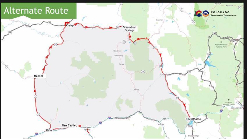
Motorists should anticipate delays on the alternate route due to additional detour traffic.
- EASTBOUND I-70: Motorists traveling eastbound from Utah or Grand Junction can reach the Denver Metro area by traveling the route above. Before detouring onto any alternate route, motorists should refer to www.cotrip.org for the latest road conditions. CDOT strongly discourages travelers from using highways south of I-70 for an alternate route, due to extensive construction closures. Motorists should not use Cottonwood Pass Road (in Eagle/Garfield counties), Hagerman Pass, or other county or forest service roads in Eagle and Garfield counties as a detour. These roads are not built for heavy traffic or commercial oversized vehicles (more below).
- WESTBOUND I-70: Motorists coming from the Denver metro area or Interstate 25 can travel the route above in reverse. Go westbound on I-70 to Silverthorne, then turn north onto CO 9. In Kremmling, travelers should turn onto westbound US Highway 40 toward Steamboat Springs. After reaching Craig, motorists can return south via CO 13 towards Rifle. Access to I-70 westbound is at Rifle.
Google Map the route
View ONLY on a desktop: https://goo.gl/maps/9sgwHRvcdMyupxbS6 | For some reason when you click the link on a mobile device, it may default to an incorrect route.
To set the directions on a mobile device, add in a second destination (Meeker), which should then correctly re-route you.

Independence Pass (Hwy 82) – OPEN | CDOT
Colorado Department of Transportation opened Independence Pass on Colorado Highway 82 for the season on Thursday, May 21, 2026. Motorists are reminded that commercial and recreational vehicles 35 feet or longer are strictly prohibited on the pass due to tight curves, steep inclines, and narrow lanes. Be sure to use caution and check COtrip.org for real-time road conditions before traveling.
NOTE: Oversized and overweight vehicles are strictly prohibited from using the Pass at any time due to narrow and winding roads and steep inclines. *Absolutely NO vehicles over 35 feet in length may use the pass at any time – there is a $1,500 fine! This includes both commercial vehicles and passenger/recreational vehicles hauling trailers that, together, exceed 35 feet. Vehicles of this length cannot negotiate certain turns and areas where the road narrows – you will get stuck.
Cottonwood Pass Road – OPEN | Eagle County
Cottonwood Pass Road (MM 2.5 in Gypsum to MM 12.5) is open. Conditions permitting, it will remain open through the fall.
Cottonwood Pass Road (Hwy 113/10A between El Jebel/Basalt and Gypsum) is open seasonally (Typically mid-May) during warmer months to local traffic. The road stays open through the fall, as conditions allow. Drivers are urged to use caution when driving this road. Traffic and weather can have a significant impact on road conditions. Vehicles should not use Cottonwood Pass Road as an I-70 detour.
Announcements are made when Cottonwood Pass Road opens in the spring, and when it closes for the season in the fall. For more information, contact the Eagle County Road & Bridge Department: 970-328-3540 or at road@eaglecounty.us.
NOTE: Cottonwood Pass Road (locally referred to as “Cottonwood Pass”) is located in Eagle/Garfield counties. This is not the same as the Cottonwood Pass that goes over the Continental Divide in Chaffee/Gunnison counties and connects Buena Vista and Crested Butte. Visit CDOT for seasonal updates on that pass.
McClure Pass (Hwy 133) | Gunnison County
Other Local Passes | 4×4 only roads
These roads are for 4×4 high-clearance vehicles ONLY. If this does not describe your vehicle, do NOT drive it. IMPORTANT: Do not use these roads unless you have the proper equipment. These roads are in areas that lack cell service, so you will not be able to call for assistance.
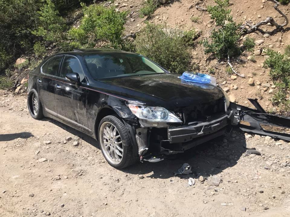
An example of what can happen to a vehicle that shouldn’t go down Hagerman Pass.
Hagerman Pass Road (#105 between Basalt and Turquoise Lake/Leadville) is a 4X4 ONLY road, accessible to high clearance vehicles. Most vehicles cannot travel down this road.
Eagle-Thomasville Rd, Powerline – Crooked Creek and Brush Creek Rd (between Eagle and Meredith) is a 4X4 ONLY road, accessible to high clearance vehicles. Most vehicles cannot travel down this road.
Fire restrictions and alerts
Wildfire is a real risk in the mountain region, especially during a drought. The Roaring Fork Valley has experienced two major fires in the last few years – the Lake Christine Fire in Basalt and the Grizzly Creek Fire near Glenwood. Our community is all too familiar with the risk of a rogue ember or spark. As a result, following area fire restrictions is very important.
Please be careful with anything that may cause a fire. During a drought, the slightest spark can start a wildfire. Most wildfires are human caused. Previous wildfires have been started by campfires that were not properly extinguished, cigarette butts, sparks from dragging chains on a vehicle, and fireworks. As Smokey Bear says – “Only you can prevent wildfires.”
Current status
Many local areas will move into Stage 2 Fire Restrictions as of June 26, 2026 – Please use caution.
- Pitkin County – Stage 2 Fire Restrictions, effective June 26, 2026
- Eagle County – Stage 2 Fire Restrictions, effective June 26, 2026
- Garfield County – Stage 2 Fire Restrictions, effective June 26, 2026
- White River National Forest – Stage 2 Fire Restrictions, effective June 26, 2026
- Bureau of Land Management (BLM) – Stage 2 Fire Restrictions, effective June 26, 2026
- Colorado Parks and Wildlife – The Basalt shooting range (Basalt SWA) is CLOSED. The status of CPW areas can be found here.
- State of Colorado
County maps
- Pitkin County – Aspen, Snowmass, Basalt
- Eagle County – Basalt, El Jebel and the Eagle River Valley (Vail)
- Garfield County – Carbondale, Glenwood Springs
- Town of Basalt map with county lines (Eagle and Pitkin)
- White River National Forest – one of the most visited national forests in the nation, the WRNF encompasses 2.3 million acres, and accounts for much of the undeveloped land in the Roaring Fork Valley.
- Bureau of Land Management – The Colorado River Valley Field Office manages 567,000 acres in Garfield, Mesa, Eagle, Pitkin, Routt and Rio Blanco counties, which include many recreation areas.
Restriction definitions
Red Flag warning
Frequently there are Red Flag warnings in effect in the Roaring Fork Valley, indicating no open burning is permitted.
- Fire Weather Watches (issued by the National Weather Service) also warn of risky fire conditions.
- Red Flag warnings typically last for a short period of time and is tied to high temperatures, high winds, and drought conditions.
- Due to the short-term nature of Red Flag warnings, this page will not include those updates.
Eagle County Fire Restriction Information
What does Stage 1 fire restrictions mean (Pitkin County)?
The following activities are prohibited under Stage 1 Fire Restrictions:
- Fireworks are not allowed under Stage I Fire Restrictions. Professional fireworks shows may be allowed through the permitting process.
- All burn permits are postponed/canceled until further notice.
- Campfires are only allowed within designated fire grates in Developed Areas (i.e. a permanent in-ground containment structure or store-bought fire pit); temporary fire pans or rock campfire rings will not be acceptable. A “Developed Area” is an area, whether within city limits or rural, that is groomed, manicured and or watered, where grasses, brush and trees are regularly attended to by a land owner. This includes residential and business areas, improved recreational areas, parks and other common areas.
- No fires of any type, including charcoal, in Undeveloped Areas.
- No smoking, except within a designated area, enclosed vehicle or building, a developed area or in an area free of all flammable material.
- No use of fireworks or explosive materials, including “exploding” targets or bullets and tracer rounds.
- Exercise common sense and industry safety practices when welding or operating an acetylene or other similar torch with open flame always clear safe areas of vegetation and combustibles.
- Operating or using an internal or external combustion engine without an approved spark-arresting device properly installed, maintained, and in effective working order meeting either the USDA Forest Service Standards or appropriate Society of Automotive Engineers (SAE) recommended practices.
What does Stage 2 fire restrictions mean?
The following activities are prohibited under Stage 2 Fire Restrictions:
- Building, maintaining, attending, or using a fire or campfire, charcoal grill, coal, wood burning stove, or sheepherder stove, including in developed camping and picnic grounds.
- EXCEPTION: Devices using pressurized liquid or gas (stoves, grills, or lanterns) that include shut-off valves are permitted when used in an area at least three feet or more from flammable material such as grasses or pine needles.
- Smoking, except within an enclosed vehicle, trailer, building, or tent.
- Using an explosive requiring fuse or blasting caps, fireworks, rockets, exploding targets, and tracers or incendiary ammunition.
- Operating or using any internal combustion engine without a spark arresting device properly installed, maintained, and in effective working order meeting either:
- Operating a chainsaw without an approved spark arrestor, without a chemical pressurized fire extinguisher, and a round-point shovel with an overall length of at least 35 inches. The extinguisher will be with the equipment operator. The shovel may be kept with fueling supplies but readily available for use.
- Welding, or operating an acetylene or other torch with open flame (except with a current permit, contract, or letter of authorization).
Complete Fire Ban
- All hot work requires a permit from the local fire authority.